Chequamegon-Nicolet National Forest

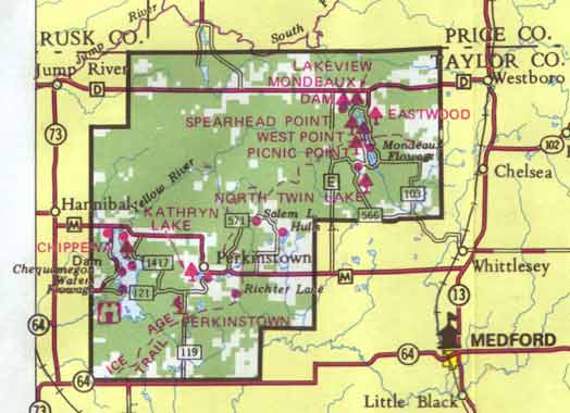
The Chequamegon-Nicolet National Forest is located in Wisconsin’s Northwoods, covering over a million and a half acres. The Chequamegon side of the forest covers about 858,400 acres in Ashland, Bayfield, Sawyer, Price, Taylor, and Vilas counties while the Nicolet side covers nearly 661,400 acres in Florence, Forest, Langlade, Oconto, Oneida, and Vilas counties.Chequamegon National Forest

The former Chequamegon and Nicolet National Forests, established in the early 1930’s, were officially combined into the Chequamegon-Nicolet National Forest in February 1998. The Forest operates out of 9 District Offices and 2 Supervisor’s Offices.

Forest Headquarters Offices

500 Hanson Lake Road
Rhinelander, WI 54501
715-362-1300

FIREWOOD ALERT for all visitors to the Chequamegon-Nicolet National Forest. Please help us stop the spread of Emerald Ash Borer, Asian Longhorn Beetle and Gypsy Moth.

Click here for more information on the national forest lands in Westboro.

Implementation

Introduction

The primary reason a community prepares a comprehensive plan is to establish a framework to influence decisions in regards to land use and development issues, to maintain the desired character of a community, and in some cases to set priorities for public expenditures. In order for this plan to be effective, it should have a set of community supported actions and/or policies that the community will follow in the hopes that at least parts of the plan will be realized. The implementation element gives decision-makers, landowners, non-profit organizations, and others a road map to move that plan to action.

Definition

The comprehensive planning law defines the implementation element as: “A compilation of programs and specific actions to be completed in a stated sequence, including proposed changes to any applicable zoning ordinances, official maps, or subdivision ordinances, to implement the objectives, policies, plans and programs.”

Consistency and Integration Between Elements

The comprehensive planning law requires that the plan provide a way to bring all the elements together and make them consistent with one another as a package to achieve the common vision and goals of the plan. In an effort to ensure that each element is consistent and integrated with the others, the planning process was coordinated by developing each element simultaneously. Based on this fact, there are no known inconsistencies or conflicts between plan elements. A consistency review of the goals, objectives, and actions/policies reveals that all elements of the plan work together as a package.

Measuring Plan Progress

Including a mechanism to measure the Town of Westboro’s progress toward achieving all aspects of this comprehensive plan is a requirement of the comprehensive planning law. The goals, objectives and action statements included for each of the plan elements are not only directives to guide town decisions, but also tools to measure who (the cooperating parties) will work on the actions and when (timeframe) they are targeted to be completed.

Plans, Updates, and Revisions

The comprehensive planning law requires that the implementation element include a process for updating the comprehensive plan at least once every 10 years. In order to ensure that the plan is an effective management tool, the Town of Westboro Planning Commission should review the plan annually to track the plan’s progress in meeting its goals and to add additional actions and recommendations as needed and as unforeseen changes occur.

The Town of Westboro should initiate its first major update of this plan by 2019. It is recommended that the information from the 2010 census be used to update pertinent parts of this plan when the data becomes available.

Plan Implementation

What follows is a list of the Town of Westboro’s goals, objectives, and action statements for housing, transportation, utilities and community facilities, natural-agricultural-cultural resources, economic development, intergovernmental cooperation and land use as derived by the Town of Westboro planning commission and citizens that participated in the overall planning process. The table also identifies responsible cooperating parties for each action as well as considering a timeframe to complete or achieve the actions.

Cooperating Parties’ abbreviations:

  • PC – Planning Commission
  • TB – Town Board
  • RTC – Rail Trail Commission
  • RD – Rural Development
  • TC – Taylor County
  • USFS – United States Forest Service
  • SD – Sanitary District
  • DNR – Department of Natural Resources
  • Tel. Co. – Telecommunication Companies
  • RLSD – Rib Lake School District
  • NWRPC – Northwest Regional Planning Commission

Land Use

Introduction

Having a land use element as part of this comprehensive plan is a way to improve local decisions that affect land. It makes subsequent zoning and other land use decisions more transparent by helping to illustrate the reasons why a decision was made. The major goal in completing this element is to create a useful tool for decision makers (elected officials and plan commissioners) to guide growth and development in the Town of Westboro, for developers as they seek planned areas to advance projects, and for residents and others to make known their desire for growth and change in the future. Many northern communities are facing the same kinds of problems as the rest of the state, including loss of community character, pollution, traffic issues, taxes at an all-time high and other infrastructure and maintenance costs that continue to strain local units of government. Many of these problems are being exacerbated by unplanned growth and development. When communities have the ability to define the way they wish to grow and develop, the extent of these problems can be significantly diminished.

Existing Land Use

An inventory of the existing land use in the Town of Westboro was conducted in the summer/fall 2006 using state and county data, aerial photography, and town review and input. The determined land use categories are approximations based on photo-identifiable land uses that were derived by linking the parcel data with the assessment database.

A standard generalized land use classification system was used to assign different land use areas into thirteen categories. A description of the land use classification system used in developing the generalized existing land use map (Map 8.1) for the Town of Westboro is as follows:

  • Agriculture – Predominate land use is agriculture where the lands include croplands, livestock grazing, and dairy farming.
  • Commercial – Retail sales establishments, restaurants, hotels/motels, and service stations, including gravel and sand pits.
  • Forest – Forest lands under private or industrial ownership. Mixed residential activity may also occur within this area.
  • Residential – Lands with structures designed for human habitation including: permanent, seasonal, and mobile housing units and recreational cabins and cottages.
  • Manufacturing – Manufacturing and industrial processing, wholesaling, warehousing and distribution, and similar activities.
  • Open Space – Private and public owned non-wooded undeveloped lands, fallow fields.
  • Government/Institutional – Lands used for government-owned administration buildings and offices; fire stations; public hospitals and health care facilities; public schools, colleges, and educational research land; and lands of fraternal organizations. Cemeteries, churches, and other religious facilities are included in this land use category.
  • Communications/Utilities – Land used for generating and/or processing electronic, communication, or water, electricity; petroleum; or other transmittable product and for the disposal, waste processing, and/or recycling of by-products.
  • Federal – Federal owned forest and non-forested lands.
  • State – State owned forested and non-forested lands.
  • County – County owned forest and non-forested lands.
  • Town – Town owned forested and non-forested lands.
  • Water – Open water areas, including natural and impounded lakes and streams.

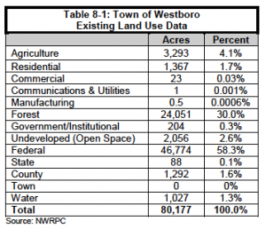
Table 8-1 illustrates the approximate acreage in each existing and use category for the Town of Westboro based on the inventory. Forestry, both private and public, represents the greatest percentage of existing land use.
 

Development Patterns

There are a number of things in a community that influence the way it develops or does not develop. The primary factors influencing the development pattern in the Town of Westboro include the following.

Land Ownership (Public Land)

The large amounts of public land (46,312 acres Chequamegon-Nicolet National Forest and 1,087 acres Taylor County Forest) in Westboro pose a barrier to development. Map 8.2 depicts land ownership in the Town of Westboro.

Commercial Land

Commercial land in the Town of Westboro consists mainly of locally owned businesses catering to local and tourist needs.

Transportation Network

There are 129.5 miles of roads in the Town of Westboro. STH 13 and STH 102 are minor arterials in the eastern portion of the town. County Road’s N, D, and E are major collectors in the town. The town’s road network limits access to some remote land parcels in the town. Further road development has the potential to open up new lands for possible development.

Surface Water Resources

A visible trend across Wisconsin is the continuous development of lakeshore parcels. Surface water is an attractive resource for a variety of reasons. Many seasonal homes on lakes have been or are being converted to year-round residences as people retire and occupy the residences permanently. Remaining undeveloped shoreland areas in the Town of Westboro are likely to continue to experience growth pressure.

Forest Management Programs

Lands that are enrolled in forestry programs such as the Managed Forest Law (MFL) program can provide some insurance that these lands will continue to be utilized for forest activities. These forested lands are under contractual obligation for either 25 or 50 years, and may or may not be renewed upon expiration.

Land Prices

Land prices depend on many factors that vary significantly from place to place. It is difficult to generalize the market price for property within a relatively small area within a county due to site-specific features and because there are a limited number of properties on the market at any given time.

In July 2009, using the search systems of local realty companies to find properties with the criteria of non-waterfront acreage with parcels 10 acres or more, 46 parcels were found. The average market price per acre for rural non-waterfront lands in Taylor County is about $1,960/acre. Although not as abundant in Taylor County, undeveloped lake frontage lots are significantly more and are normally sold on a per foot basis. This information is intended to represent a snapshot of land market sales in Taylor County and should not be considered a comprehensive analysis of real estate prices as a whole.

Land Trends

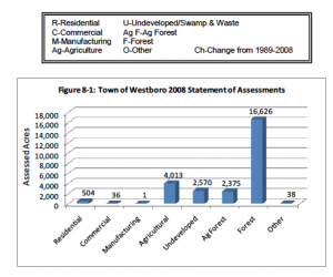
Wisconsin Department of Revenue assessment statistics were used to determine land use trends in the Town of Westboro. Land assessment data can be used to conduct a simplified land use analysis and for examining trends. Figure 8-1 exhibits the total 2008 acreage as reported on February 10, 2009 in each of the tax assessment classes. Currently, the statutory classes of real estate used for assessment purposes are Residential, Commercial, Manufacturing, Agricultural, Undeveloped (formerly Swamp and Waste), Agricultural Forest, Forest and Other.

1. Residential – any parcel or part of a parcel of untilled land that is not suitable for the production of row crops, on which a dwelling or other of human habitat is located.

2. Commercial – properties where the predominant use is the selling of merchandise or a service. Apartment buildings of four or more units and office buildings.

3. Manufacturing – consists of all property used for manufacturing, assembling, processing, fabricating, or milling tangible personal property for profit. It also includes establishments engaged in assembling component parts of manufactured products.

4. Agriculture – land, exclusive of buildings and improvements that is devoted primarily to agricultural use, as defined by rule.

5. Undeveloped – bog, marsh, lowland brush, uncultivated land zoned as shoreland, wetlands and other non-productive lands not elsewhere classified.

5m. Agricultural Forest – land that is producing or is capable of producing

commercial forest products, if the land satisfies any of three conditions.

6. Forest – productive forestland that is producing or is capable of producing commercial forest products.

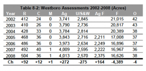
7. Other – includes all tax exempt lands. Real estate assessments are also used to display trends in land use to aid in predicting future trends. Because this data covers extensive time periods, they are useful in conducting a simplified analysis for each real estate class. Trends in tax class assessment from 2002 through 2008 are depicted for residential, commercial, manufacturing, agriculture, undeveloped/swamp & waste, forest and other in Figure 8-1 and Table 8-2.
 

Zoning

The Town of Westboro does not have a local zoning ordinance and Taylor County has not adopted a general comprehensive zoning ordinance governing the unincorporated areas of the county. The Taylor County Zoning Department is responsible for administrating and enforcing some county codes, including the county’s Shoreland Zoning (31), Subdivision Control (33), Floodplain Zoning (29), Sanitary Code (32), Airport Zoning (35), Contaminated Soil Control (37), Non-Metallic Mining Reclamation (46), Rural Road & Building Identification (61), and Recycling Authority (28) ordinances. The department consists of a Zoning Administrator who provides advisory, educational and enforcement supervision over environmental health problems of the entire county.

Shoreland Zoning

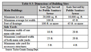
All unincorporated areas of Taylor County located within 1,000 feet of the ordinary high water mark of navigable lakes, ponds, or flowages and within 300 feet of the ordinary high water mark of navigable rivers or streams, or to the edge of the floodplain, whichever distance is greater is regulated by the Taylor County Shoreland Zoning Code (31). The Taylor County Shoreland Zoning Code establishes development standards for lands adjacent to county surface waters. The dimensions of building sites in shoreland areas are as follows in Table 8-3.
 

Building Permit Breakdown

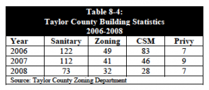
The Town of Westboro requires building permits for new construction. Table 8-4 details building statistics in Taylor County from 2006 to 2008. Sanitary permits include new and replacement systems. Zoning permits are issued for new building construction, remodeling, excessive grading, billboards and anything in the shoreland area. A Certified Survey Map (CSM) is required for lots less than ten acres.
 

Opportunities for Redevelopment

Opportunities for redevelopment include infill, brownfield site redevelopment, and obsolete and dilapidated building and building sites. Although no specific areas have been identified, there may be parcels of land in the Town of Westboro that could use varying levels of redevelopment. Because the vast majority of the town is undeveloped, redevelopment will occur when and where practical in order to protect land values and neighboring properties.

Existing & Potential Land Use Conflicts

As growth occurs in the Town of Westboro, there will likely be increasing land use conflicts. Future rural growth will likely require the conversion and fragmentation of farmland, forests, and open space areas.

Conflicts between non-farm development and surrounding farms and forestry activities could become increasingly common. Other potential rural land uses that could conflict with neighboring uses include large-scale farm operations, nonmetallic mining operations, late night farming operations and rural manufacturing plants. While this plan and its process sought to minimize future land use conflicts, continued local government and developer related coordination must occur as few ordinances are in place that can directly impact land use conflicts.

The planning process was useful for minimizing potential land use conflicts between Westboro and surrounding communities and the county by offering intergovernmental discussions and seeking input by sharing and goals and objectives, town maps, and plan narrative before adoption.

Land Use Projections

While it is difficult to predict exactly what future land use activity will take place, the planning process sought to identify projected demand for future land use activities covering a 20-year planning period (in five-year increments) for residential, agricultural, commercial and manufacturing (industrial) land use. Projected land use changes for residential considered future population projections and past residential assessment data, while commercial, manufacturing, and agricultural projections utilized past assessment data.

Residential

Between 2008 and 2030, the Town of Westboro is projected to need 135 more acres for residential land use, approximately 6 acres per year. Future residential acreage was determined by calculating the assessed acreage per person. The estimated future acreage per person was then calculated based on the historical yearly percentage change. These numbers were then multiplied by the WDOA population estimates, resulting in the estimated assessed residential acreage.


Commercial

The amount of land (acres) assessed for commercial purposes was 36 acres in 2008. Projections based on historic trends indicate that by the year 2030 commercial land will increase by 10 acres (Table 8-6).


Manufacturing

In 2008, there was only one acre of land assessed for manufacturing purposes in the Town of Westboro. Due to the very small amount of change in manufacturing acreage in the Town throughout history, change in acreage for manufacturing over the 20-year planning horizon is expected to be minimal.

Agricultural

Projections made using data from 1990-2008 indicate that the Town of Westboro will lose an average of 52 acres per year for the next 20 years. All together, it’s estimated the town will lose 1,144 acres by 2030. However, it should be noted that these are only estimates based on assessment trends, and a number of factors could affect future agricultural acreage in the Town.


Future Land Use

The future land use map for the Town of Westboro is the visual guide to planning by bringing together most, if not all of the elements of the comprehensive plan such as agricultural and natural resources, economic development, housing, utilities and community facilities, and transportation. It’s a map of what the town wants to have happen, not a prediction or projection based on a formula.

As part of the planning process, the Town of Westboro Planning Commission was provided an existing land use map, demographic and other background data. The result of the input provided created perspective on future land use direction for the town. The direction towards the future is portrayed in Map 8.3. In most cases, land uses are identified to take advantage of cost effective extension of public infrastructure, where available. The map is intended to serve as a general guide for future growth and development in the Town of Westboro over a 20-year planning horizon. It is important to note the future land use map is not an official map nor is it a zoning map.

Future Land Use Categories

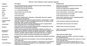
A total of fifteen future land use categories were identified to assist in developing a future land use map. These categories along with a description and intended use are shown in Table 8-8 on the following page.


Economic Development

Introduction

This element will present information about the economy within the Town of Westboro. Economic development, which can be defined as the type and level of business activity within an area, is often based on a combination of factors including market forces, regulation, and the extent of the local government’s encouragement and participation. The Town of Westboro has historically been a rural town of primarily agriculture and forestry activity. Most business growth concerning residents of Westboro occurs outside the town in areas where infrastructure is readily available.

Labor Force

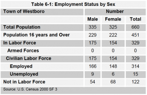
The labor force is comprised of employed persons and those seeking employment, and excludes persons in the armed forces and those under age 16. Table 6-1 gives an overview of some of the characteristics of the population and labor force in the Town of Westboro.

Economic Base

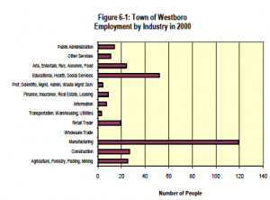
The economic base of a community includes all the industries that provide jobs in a given community or geographic location. Figure 6-1 displays the number of employed residents in the Town of Westboro by industry sector from Census 2000. Nearly 38 percent (119) of town residents are employed in the manufacturing industry sector, which by far is the leading employment industry in the Town of Westboro. Considering the proximity of the Cities of Medford and Marshfield, many residents are likely employed in those larger municipalities.


Environmentally Contaminated Sites

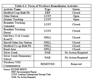
The WDNR and EPA are urging the clean up of contaminated commercial and/or industrial sites so they may be used for uses that are more productive. DNR’s Bureau for Remediation and Redevelopment Tracking System (BRRTS) on the Web allows you to find information on incidents that contaminated soil or groundwater. These “Activities” include Spills, Leaks, other cleanups and sites where no action was needed. There are currently twelve records of environmentally contaminated sites in the Town of Westboro, two of which have a status of ‘Open’. Table 6-2 details the environmentally contaminated sites in the Town of Westboro.


Attracting/Retaining Business and Industry

The Town of Westboro has a number of strengths and weakness for attracting and retaining business and industry. These include:

A. Strengths

  • State Highway 13
  • County Road D
  • Natural Resources (clean air and water)
  • Low crime rate
  • Visible planning
  • Good people/family values
  • Decent school system
  • Recreational opportunities

B. Weaknesses

  • Limited sewer system to handle industry within the village area
  • Property taxes too high
  • Limited jobs

Desired Business and Industry

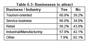
The Town of Westboro Comprehensive Planning survey asked residents to select the types of businesses that they believe are the most important for the Town of Westboro to encourage. The categories included tourism, service, retail, industrial/manufacturing, and other. The business/industry chosen by the highest number of residents in the Town of Westboro was ‘service business’, with 66 percent of residents surveyed feeling it should be encouraged. Tourism-oriented was second with 60.8 percent. Table 6-3 displays the results of this survey question.


Economic Development Assistance and Programs

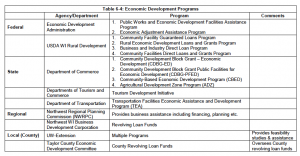
Programs to start, support, stimulate and assist economic development activities exist at the federal, state, regional and county (local) levels. Table 6-4 identifies the major agencies and programs that are most likely to be used in Westboro for economic development efforts.


Intergovernmental Cooperation

Introduction

This analysis presents an inventory of existing methods that the Town of Westboro uses to coordinate with other units of government, including: Taylor County, adjacent towns, Rib Lake School District, State of Wisconsin, and regional and federal government. The purpose of this analysis is to identify the existing cooperative agreements and summarize the major challenges and issues regarding intergovernmental cooperation, including:

  • Opportunities to reduce or eliminate duplication of services;
  • Incompatible goals, objectives, actions and policies;
  • Opportunities for joint planning and decision-making;
  • Mechanisms for conflict resolution.

Methods for cooperation and coordination primarily take the form of intergovernmental agreements, leases, contracts, and regulatory authority. These can occur between the Town of Westboro and other local, regional, state or federal entities. The following is a brief description and analysis of the relationship of Westboro to other governmental units and various functional areas and services that require the Town of Westboro to coordinate and cooperate at different levels.

Governmental Relationships

Adjacent Towns

The Town of Westboro shares borders with six towns in Taylor County. They include the Towns of Rib Lake (east), Greenwood, Chelsea, Molitor, and Grover (south), and Jump River (west). Westboro also shares borders with three towns, Kennan, Ogema, and Hill, in Price County to the north. The Town of Westboro maintains a cooperative relationship with all surrounding towns.

Taylor County

Taylor County provides several services to the Town of Westboro including: law enforcement through the Sheriff’s Department, 9-1-1 dispatch service and ambulance, maintenance and improvements to county highways and parks, planning and permitting oversight regarding shore land, wetland and floodplain regulation, private sewage system regulation, oversight on compliance with soil and water conservation policies for the Farmland Preservation Program and administration of the recycling program. According to town officials, Westboro has a good working relationship with Taylor County.

Regional Agencies

The Northwest Regional Planning Commission (NWRPC) is the only regional planning agency serving the Town of Westboro. NWRPC is a venture of ten counties and five tribal nations. The Commission assists in improving and enhancing the economic conditions in the region to provide a positive economic impact and improve the economic prosperity of the area. NWRPC has a respectable working relationship with the Town of Westboro.

School District

The Town of Westboro is in the Rib Lake School District. Facilities, which include an elementary school, middle school, and high school, are located in the Village of Rib Lake. The Town of Westboro is therefore within the Rib Lake School taxing district and does not see this changing over the 20-year planning period.

State of Wisconsin

The Town of Westboro has little direct contact with State agencies. However, State agencies regulate certain activities such as planning, development and maintenance of State roads/highways, natural resource protection planning and enforcement, State Patrol law enforcement, as well as other policies and programs at the State level of government. The Town of Westboro involvement with State government is minimal but has been an ongoing positive relationship.

Federal Government

Cooperation and coordination with federal government agencies is limited to the Department of Agriculture and the U.S. Forest Service and their management of the Chequamegon-Nicolet National Forest, which covers approximately 46,312 acres in the town.

Existing Agreements Affecting Boundaries

The Town of Westboro does not have any cooperative boundary agreements or plans with any other jurisdictions pursuant to §66.0307.

General Intergovernmental Agreements

Intergovernmental agreements are the most common form of agreement used by communities. Communities have used these agreements for years, often in the framework of sharing public services such as police, fire and road maintenance. Currently, the Town of Westboro has several general intergovernmental agreements for sharing and/or getting services with other municipalities and entities. These include agreements and/or contracts with:

  • Taylor County for law enforcement
  • Taylor County Ambulance Service
  • Surrounding Fire Service with Rib Lake, Ogema, Prentice, and Medford
  • Adjoining townships for shared road maintenance
  • U.S. Forest Service
  • WI State Elections Board
  • Wisconsin Valley Library Service

Existing/Potential Conflicts

Intergovernmental issues between municipalities sometimes surface over a number of different matters. The comprehensive planning process examined the existing and potential conflict situation(s) in the Town of Westboro.

Existing Conflicts

  • No conflicts identified.

Potential Conflicts

  • No conflicts identified

Conflict Resolution

The Comprehensive Planning Law requires that the Town of Westboro identify a process to resolve conflicts. What follows is a discussion of formal and informal techniques for resolving conflicts. Each dispute and/or conflict resolution technique has a purpose. When considering how to resolve a conflict, the town will need to determine whether the conflict can be settled out of court and which resolution process is the most appropriate for the type of conflict.

Mediation is a cooperative process involving two or more parties and a mediator. The mediator, a neutral third party with special skills and training in dispute resolution, helps the parties voluntarily reach a mutually agreeable settlement of the issue in dispute.

Binding arbitration is a process where a neutral person is given the authority to make a legally binding decision and is used only with the consent of all of the parties. The parties present evidence and examine witnesses and the arbitrator makes a determination based on evidence.

Non-binding arbitration is a technique in which a neutral person is given the authority to render a non-binding decision as a basis for subsequent negotiations between the parties after the parties present evidence and examine the witnesses.

Early neutral evaluation is a process in which a neutral person evaluates brief written and oral presentations early in the litigation process. The neutral person provides an initial appraisal of the merits of the case with suggestions for conducting discovery and obtaining a legal ruling to resolve the case as efficiently as possible.

A focus group can be used to resolve disputes by using a panel of citizens selected in a manner agreed upon by all of the parties. The citizens hear presentations from the parties and, after hearing the issues, the focus group deliberates and renders an advisory opinion.

A mini-trial consists of presentations by the parties to a panel of selected and authorized by all the parties to negotiate a settlement of the dispute that, after the presentations, considers the legal and factual issues and attempts to negotiate a settlement.

A moderated settlement conference is a process in which conferences are conducted by a neutral person, who hears brief presentations from the parties, in order to facilitate negotiations. The neutral person renders an advisory opinion in aid of negotiation.

A summary jury trial is a technique where attorneys make abbreviated presentations to a small jury selected from the regular jury list. The jury renders an advisory decision to help the parties assess their position to aid future negotiation.

Housing

Introduction

Housing is very important to the citizens of the Town of Westboro, representing in many cases the largest expenditure individuals will make. This element will look at different characteristics of the housing stock in the Town of Westboro,and in some cases neighboring towns and Taylor County, to help make sure that the needs of present and future residents are addressed in this plan.

Housing Inventory

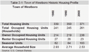
Table 2-1 details historic housing information from 1980 to 2000. In that 20-year period, Westboro added 32 housing units, 62.5 percent of which were occupied. The gradual decline in average household size is a trend common throughout northern and rural Wisconsin. The central trends causing this decline include the out-migration of inhabitants over the age of 18 for work or school, overall smaller family sizes, fewer families with children moving into the town, fewer children being born to Town of Westboro residents, and a steady divorce rate. Additionally, many households are composed of retired couples or are single person households.

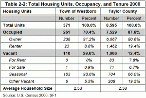
Table 2-2 compares housing occupancy and tenure for Town of Westboro and Taylor County. Percentage wise, Westboro has a much lower occupancy rate than the County. There is a large difference between percentages of owner and renter-occupied housing units in the Town of Westboro and Taylor County. Westboro has a higher percentage of owner-occupied units than Taylor County, while the County has a higher percentage of renter-occupied units than Westboro. There is also a very large difference in the types of vacant units between the Town and the County. Almost 94 percent of vacant units in the Town are seasonal, compared to the County’s 66 percent. Average household size in Westboro is comparable to that of Taylor County.

Housing Age

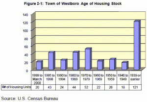
Figure 2-1 shows housing age for the community. In the Town of Westboro, data shows that nearly 33% of the local housing stock was built before 1939. Recent housing growth from the 1990’s makes up over 23 percent of the total housing stock.

Housing Value

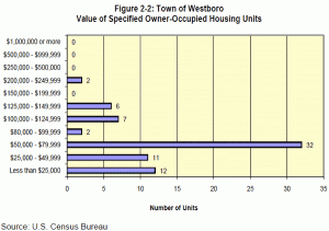
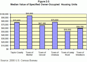
Figures 2-2 and 2-3 display home value statistics. Figure 2-2 breaks down the value of specified owner-occupied units in the Town of Westboro. According to the 2000 U.S. Census, most homes (32) are valued between $50,000 and $79,999. Figure 2-3 shows that the median housing value for specified owner occupied units in the Town of Westboro is higher than the median value for the Town of Jump River, but lower than the median values for other surrounding towns and Taylor County.

Physical Housing Stock Characteristics

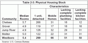
The following tables (Table 2-2 through 2-4 looks at several select factors that measure the makeup of housing in the Town of Westboro. Table 2-2 compares some physical housing stock characteristics of Westboro to its surrounding towns. Most housing units in Westboro are 1-unit detached, meaning the structure is detached from any other house; that is, with open space on all four sides. Homes that lack complete kitchen and plumbing facilities in the Town are more than likely seasonal housing units used for occasional use.

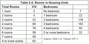
Table 2-3 details the number of rooms in housing units in the Town of Westboro. Most homes in the town average between five and six total rooms and most have three bedrooms.

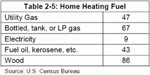
Wood is the most common home heating fuel used in the Town of Westboro, as shown in Table 2-4. It is followed by bottled,tank, or LP gas.

Survey Results on Housing

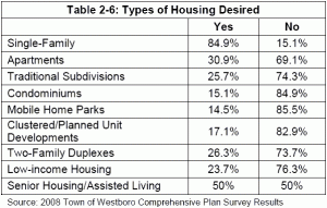
Town of Westboro residents overwhelmingly desire single family housing developments, as nearly 85 percent of surveyed residents favored them.

Housing Assistance Policies and Programs

Housing assistance programs are available through a number of different local, state, federal and regional organizations. This listing of programs may help the Town of Westboro to:

  • Promote development of housing for residents of the Town of Westboro.
  • Provide a range of housing choices that meet the needs of persons of all income levels and of all age groups and persons with special needs.
  • Promote the availability of land for the development or redevelopment of low and moderate-income housing.
  • Maintain or rehabilitate the Town’s existing housing stock.

Taylor County Housing Authority offers assistance for the following program areas.

Housing Cost Reduction Initiative (HCRI)

HCRI assistance is intended for lower income households.  Eligible program expenditures include interest-free loans for past due rent, past due utility bills, first month’s rent, security deposits and utility deposits. Other program offerings may include assistance to homeowners with past due mortgage payments, property taxes, utilities and homeowner’s insurance, and homebuyers’ assistance in the form of down payments and closing costs. Additionally, short-term renters assistance may be available for rent and security / utility deposits and past due utilities. Availability of funding is based on the level of available funds.

Section 8 Long-Term Rental Subsidy Program

This long-term rental subsidy program is available to low income Taylor County families. To be eligible, you must have dependents, be 62 years or older, or disabled receiving SSI. Certain income limits apply. Based on monthly income, we may assist in part or in whole, with monthly rental payments on a long-term basis. Applicants must sign a one-year lease with the landlord, be current on utility bills and maintain the residence in a clean, safe and sanitary condition.

Community Development Block Grant (CDBG)

CDBG funds are available on a limited basis for home repairs to income-eligible homeowners. We will provide help with siding, wiring, heating, roofing, plumbing, insulation, grab bars, foundation repairs, well / septic systems, accessibility modifications and replacing doors and windows. Emergency funds are available for well / septic replacement, lead-based paint / asbestos abatement and hazardous wiring, heating or roofing.

HCRI Home Program

Taylor County Housing Authority has funds available to income-eligible households for purchasing a home. This must be a first-home purchase, and the home must be located in Taylor County. We can assist with a 0 percent interest, deferred payment home loan for 10 percent of a down payment and / or 100 percent of closing costs. The loan becomes payable in full when the home purchased is no longer the primary residence.

Telecommunication and Electric Transmission

Telecommunication

Local telephone service providers in the Town of Westboro include Frontier Citizens Communication. There is currently one cell phone tower in the town. Internet access is available across the entire region through local telephone (dial-up through out the area and DSL in specific regions) or thru satellite dish from a variety of providers.

Power Plants / Transmission Lines

There are no power plants located in the Town of Westboro. There are two transmission lines in the eastern portion of the town. One line starts in the City of Medford, travels north through the Town of Chelsea, and winds its way into the Town of Westboro; while the other connects this line to State Highway 13. The four electric providers that serve the town include Taylor Electric, Jump River Electric, Price Electric, and Xcel Energy.

Trails

Pine Line Trail

The Pine Line Trail, also known as State Corridor Trail 23, runs north-south through the eastern portion of the Town of Westboro. This converted rail-trail follows the route traveled by the Wisconsin Central Railroad. The Pine Line stretches 26.2 miles from Medford in Taylor County to Prentice in Price County. From April 1 to November 30, the Pine Line is open for hiking, cycling, and jogging. From December 1 through March 31, it is open for snowmobiling (weather permitting) and ATV’s.

Ice Age National Scenic Trail

The Ice Age National Scenic Trail is a thousand-mile footpath located entirely within Wisconsin. The trail runs through Taylor County, a portion of it passing through the Town of Westboro and winding around the Mondeaux Flowage. It was designated to highlight unique Ice Age landscape features, and to provide access to some of the state’s natural areas. Learn more at the Department of Interior’s website.

Parks/Recreation Areas

Parks and recreation areas in the Town of Westboro consist of:

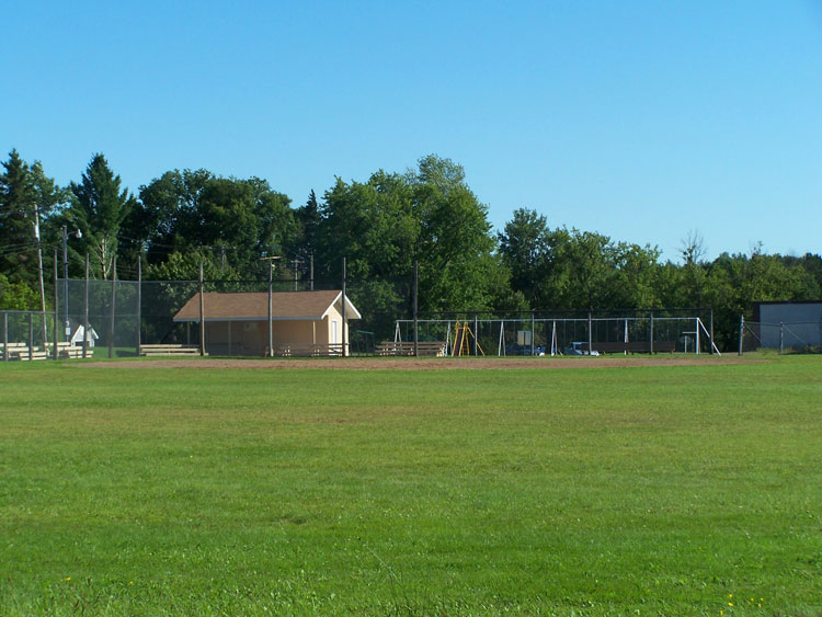
Town of Westboro, Wisconsin Ball Park and Playground

Town of Westboro, Wisconsin Ball Park and Playground at the site of the old Silver Creek School

Other Government Facilities

Westboro Town Hall

The town hall is located at N8835 Business Hwy 13. Town meetings are held the 2nd Saturday of each month at 8:00 A.M. However, in 2011 the library and town hall will relocate to 2nd Street and occupy the former St. Theresa Catholic Church.