Introduction
Having a land use element as part of this comprehensive plan is a way to improve local decisions that affect land. It makes subsequent zoning and other land use decisions more transparent by helping to illustrate the reasons why a decision was made. The major goal in completing this element is to create a useful tool for decision makers (elected officials and plan commissioners) to guide growth and development in the Town of Westboro, for developers as they seek planned areas to advance projects, and for residents and others to make known their desire for growth and change in the future. Many northern communities are facing the same kinds of problems as the rest of the state, including loss of community character, pollution, traffic issues, taxes at an all-time high and other infrastructure and maintenance costs that continue to strain local units of government. Many of these problems are being exacerbated by unplanned growth and development. When communities have the ability to define the way they wish to grow and develop, the extent of these problems can be significantly diminished.
Existing Land Use
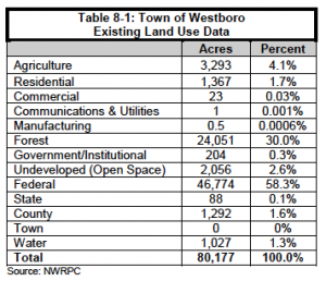
An inventory of the existing land use in the Town of Westboro was conducted in the summer/fall 2006 using state and county data, aerial photography, and town review and input. The determined land use categories are approximations based on photo-identifiable land uses that were derived by linking the parcel data with the assessment database.
A standard generalized land use classification system was used to assign different land use areas into thirteen categories. A description of the land use classification system used in developing the generalized existing land use map (Map 8.1) for the Town of Westboro is as follows:
- Agriculture – Predominate land use is agriculture where the lands include croplands, livestock grazing, and dairy farming.
- Commercial – Retail sales establishments, restaurants, hotels/motels, and service stations, including gravel and sand pits.
- Forest – Forest lands under private or industrial ownership. Mixed residential activity may also occur within this area.
- Residential – Lands with structures designed for human habitation including: permanent, seasonal, and mobile housing units and recreational cabins and cottages.
- Manufacturing – Manufacturing and industrial processing, wholesaling, warehousing and distribution, and similar activities.
- Open Space – Private and public owned non-wooded undeveloped lands, fallow fields.
- Government/Institutional – Lands used for government-owned administration buildings and offices; fire stations; public hospitals and health care facilities; public schools, colleges, and educational research land; and lands of fraternal organizations. Cemeteries, churches, and other religious facilities are included in this land use category.
- Communications/Utilities – Land used for generating and/or processing electronic, communication, or water, electricity; petroleum; or other transmittable product and for the disposal, waste processing, and/or recycling of by-products.
- Federal – Federal owned forest and non-forested lands.
- State – State owned forested and non-forested lands.
- County – County owned forest and non-forested lands.
- Town – Town owned forested and non-forested lands.
- Water – Open water areas, including natural and impounded lakes and streams.
Table 8-1 illustrates the approximate acreage in each existing and use category for the Town of Westboro based on the inventory. Forestry, both private and public, represents the greatest percentage of existing land use.
Development Patterns
There are a number of things in a community that influence the way it develops or does not develop. The primary factors influencing the development pattern in the Town of Westboro include the following.
Land Ownership (Public Land)
The large amounts of public land (46,312 acres Chequamegon-Nicolet National Forest and 1,087 acres Taylor County Forest) in Westboro pose a barrier to development. Map 8.2 depicts land ownership in the Town of Westboro.
Commercial Land
Commercial land in the Town of Westboro consists mainly of locally owned businesses catering to local and tourist needs.
Transportation Network
There are 129.5 miles of roads in the Town of Westboro. STH 13 and STH 102 are minor arterials in the eastern portion of the town. County Road’s N, D, and E are major collectors in the town. The town’s road network limits access to some remote land parcels in the town. Further road development has the potential to open up new lands for possible development.
Surface Water Resources
A visible trend across Wisconsin is the continuous development of lakeshore parcels. Surface water is an attractive resource for a variety of reasons. Many seasonal homes on lakes have been or are being converted to year-round residences as people retire and occupy the residences permanently. Remaining undeveloped shoreland areas in the Town of Westboro are likely to continue to experience growth pressure.
Forest Management Programs
Lands that are enrolled in forestry programs such as the Managed Forest Law (MFL) program can provide some insurance that these lands will continue to be utilized for forest activities. These forested lands are under contractual obligation for either 25 or 50 years, and may or may not be renewed upon expiration.
Land Prices
Land prices depend on many factors that vary significantly from place to place. It is difficult to generalize the market price for property within a relatively small area within a county due to site-specific features and because there are a limited number of properties on the market at any given time.
In July 2009, using the search systems of local realty companies to find properties with the criteria of non-waterfront acreage with parcels 10 acres or more, 46 parcels were found. The average market price per acre for rural non-waterfront lands in Taylor County is about $1,960/acre. Although not as abundant in Taylor County, undeveloped lake frontage lots are significantly more and are normally sold on a per foot basis. This information is intended to represent a snapshot of land market sales in Taylor County and should not be considered a comprehensive analysis of real estate prices as a whole.
Land Trends
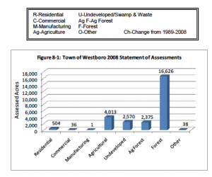
Wisconsin Department of Revenue assessment statistics were used to determine land use trends in the Town of Westboro. Land assessment data can be used to conduct a simplified land use analysis and for examining trends. Figure 8-1 exhibits the total 2008 acreage as reported on February 10, 2009 in each of the tax assessment classes. Currently, the statutory classes of real estate used for assessment purposes are Residential, Commercial, Manufacturing, Agricultural, Undeveloped (formerly Swamp and Waste), Agricultural Forest, Forest and Other.
1. Residential – any parcel or part of a parcel of untilled land that is not suitable for the production of row crops, on which a dwelling or other of human habitat is located.
2. Commercial – properties where the predominant use is the selling of merchandise or a service. Apartment buildings of four or more units and office buildings.
3. Manufacturing – consists of all property used for manufacturing, assembling, processing, fabricating, or milling tangible personal property for profit. It also includes establishments engaged in assembling component parts of manufactured products.
4. Agriculture – land, exclusive of buildings and improvements that is devoted primarily to agricultural use, as defined by rule.
5. Undeveloped – bog, marsh, lowland brush, uncultivated land zoned as shoreland, wetlands and other non-productive lands not elsewhere classified.
5m. Agricultural Forest – land that is producing or is capable of producing
commercial forest products, if the land satisfies any of three conditions.
6. Forest – productive forestland that is producing or is capable of producing commercial forest products.
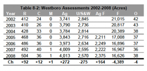
7. Other – includes all tax exempt lands. Real estate assessments are also used to display trends in land use to aid in predicting future trends. Because this data covers extensive time periods, they are useful in conducting a simplified analysis for each real estate class. Trends in tax class assessment from 2002 through 2008 are depicted for residential, commercial, manufacturing, agriculture, undeveloped/swamp & waste, forest and other in Figure 8-1 and Table 8-2.
Zoning
The Town of Westboro does not have a local zoning ordinance and Taylor County has not adopted a general comprehensive zoning ordinance governing the unincorporated areas of the county. The Taylor County Zoning Department is responsible for administrating and enforcing some county codes, including the county’s Shoreland Zoning (31), Subdivision Control (33), Floodplain Zoning (29), Sanitary Code (32), Airport Zoning (35), Contaminated Soil Control (37), Non-Metallic Mining Reclamation (46), Rural Road & Building Identification (61), and Recycling Authority (28) ordinances. The department consists of a Zoning Administrator who provides advisory, educational and enforcement supervision over environmental health problems of the entire county.
Shoreland Zoning
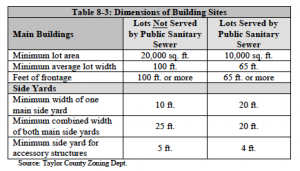
All unincorporated areas of Taylor County located within 1,000 feet of the ordinary high water mark of navigable lakes, ponds, or flowages and within 300 feet of the ordinary high water mark of navigable rivers or streams, or to the edge of the floodplain, whichever distance is greater is regulated by the Taylor County Shoreland Zoning Code (31). The Taylor County Shoreland Zoning Code establishes development standards for lands adjacent to county surface waters. The dimensions of building sites in shoreland areas are as follows in Table 8-3.
Building Permit Breakdown
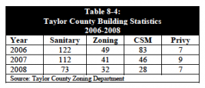
The Town of Westboro requires building permits for new construction. Table 8-4 details building statistics in Taylor County from 2006 to 2008. Sanitary permits include new and replacement systems. Zoning permits are issued for new building construction, remodeling, excessive grading, billboards and anything in the shoreland area. A Certified Survey Map (CSM) is required for lots less than ten acres.
Opportunities for Redevelopment
Opportunities for redevelopment include infill, brownfield site redevelopment, and obsolete and dilapidated building and building sites. Although no specific areas have been identified, there may be parcels of land in the Town of Westboro that could use varying levels of redevelopment. Because the vast majority of the town is undeveloped, redevelopment will occur when and where practical in order to protect land values and neighboring properties.
Existing & Potential Land Use Conflicts
As growth occurs in the Town of Westboro, there will likely be increasing land use conflicts. Future rural growth will likely require the conversion and fragmentation of farmland, forests, and open space areas.
Conflicts between non-farm development and surrounding farms and forestry activities could become increasingly common. Other potential rural land uses that could conflict with neighboring uses include large-scale farm operations, nonmetallic mining operations, late night farming operations and rural manufacturing plants. While this plan and its process sought to minimize future land use conflicts, continued local government and developer related coordination must occur as few ordinances are in place that can directly impact land use conflicts.
The planning process was useful for minimizing potential land use conflicts between Westboro and surrounding communities and the county by offering intergovernmental discussions and seeking input by sharing and goals and objectives, town maps, and plan narrative before adoption.
Land Use Projections
While it is difficult to predict exactly what future land use activity will take place, the planning process sought to identify projected demand for future land use activities covering a 20-year planning period (in five-year increments) for residential, agricultural, commercial and manufacturing (industrial) land use. Projected land use changes for residential considered future population projections and past residential assessment data, while commercial, manufacturing, and agricultural projections utilized past assessment data.
Residential
Between 2008 and 2030, the Town of Westboro is projected to need 135 more acres for residential land use, approximately 6 acres per year. Future residential acreage was determined by calculating the assessed acreage per person. The estimated future acreage per person was then calculated based on the historical yearly percentage change. These numbers were then multiplied by the WDOA population estimates, resulting in the estimated assessed residential acreage.
Commercial
The amount of land (acres) assessed for commercial purposes was 36 acres in 2008. Projections based on historic trends indicate that by the year 2030 commercial land will increase by 10 acres (Table 8-6).
Manufacturing
In 2008, there was only one acre of land assessed for manufacturing purposes in the Town of Westboro. Due to the very small amount of change in manufacturing acreage in the Town throughout history, change in acreage for manufacturing over the 20-year planning horizon is expected to be minimal.
Agricultural
Projections made using data from 1990-2008 indicate that the Town of Westboro will lose an average of 52 acres per year for the next 20 years. All together, it’s estimated the town will lose 1,144 acres by 2030. However, it should be noted that these are only estimates based on assessment trends, and a number of factors could affect future agricultural acreage in the Town.
Future Land Use
The future land use map for the Town of Westboro is the visual guide to planning by bringing together most, if not all of the elements of the comprehensive plan such as agricultural and natural resources, economic development, housing, utilities and community facilities, and transportation. It’s a map of what the town wants to have happen, not a prediction or projection based on a formula.
As part of the planning process, the Town of Westboro Planning Commission was provided an existing land use map, demographic and other background data. The result of the input provided created perspective on future land use direction for the town. The direction towards the future is portrayed in Map 8.3. In most cases, land uses are identified to take advantage of cost effective extension of public infrastructure, where available. The map is intended to serve as a general guide for future growth and development in the Town of Westboro over a 20-year planning horizon. It is important to note the future land use map is not an official map nor is it a zoning map.
Future Land Use Categories
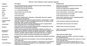
A total of fifteen future land use categories were identified to assist in developing a future land use map. These categories along with a description and intended use are shown in Table 8-8 on the following page.
If you can't find what you are looking for on this website, please provide feedback.

